Panama City, 14 December
2010 - From deforestation in Guatemala to
the effects of mining in Colombia, a new
atlas produced by the United Nations
Environment Programme (UNEP) uses over 200
striking satellite images to highlight the
most pressing environmental issues in Latin
America and the Caribbean.
Latin America and the
Caribbean - Atlas of our changing environment
represents the first effort to analyze changes
taking place in the region's environment,
combining precise and striking satellite
images with analysis based on rigorous data.
The Atlas is an indispensable tool in formulating
the future actions and public policies needed
to achieve more sustainable development
in the region.
The images highlight
the region's richness and diversity of environments,
ecosystems, species and landscapes. They
also show, however, that this natural wealth
is currently under considerable pressure
as a result of the prevailing economic development
models - which, while leading to growth,
have also produced significant social and
environmental changes.
The Atlas is divided
into three parts. The first two bring together
regional information, while the third outlines
relevant environmental issues in each country,
analysing 65 specific national cases. The
more than 200 satellite images, maps and
graphs provide a clear sense of the rapid
urbanisation that has taken place, often
without adequate planning, in places such
as the Metropolitan Area of San José
(Costa Rica) and San Salvador (El Salvador).
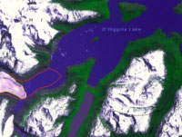
The effects of climate
change are evident in satellite images of
glaciers in Chilean and Argentine Patagonia.
Deforestation can be seen in countries such
as Brazil, the Plurinational State of Bolivia,
Mexico, Guatemala and Haiti. The impact
of mining is illustrated through pictures
of La Guajira (Colombia) and Cerro de Pasco
(Peru), while high-resolution images show
the impact of the natural disasters that
struck Haiti in January 2010. Other environmental
problems highlighted by the Atlas include
changes in land use, loss of biodiversity
and degradation of coastal areas.
The State of the Region's
Environment: Principal Findings
The growth of cities:
The absence of proper urban and land-use
planning has created major problems in the
cities of the region. Latin American cities
are the most compact in the world, have
the highest-density urban centres and present
major challenges such as waste management
and waste water treatment.
Land Degradation: Although
the region still has areas of lush vegetation,
and houses one of the world's foremost reserves
of biocapacity, land degradation - including
desertification and the erosion of soils
and coastlines - is evident throughout the
continent. Desertification currently affects
more than 600 million hectares in arid,
semiarid and subhumid areas in the region.
Profound changes in
agriculture: Land for agricultural use increased
at a rate of 0.13% per year between 2003
and 2005, resulting in the loss of forests
and other habitats. This change has been
accompanied by an even more profound one:
major food crops such as potatoes, cassava,
rice and wheat have decreased on a per capita
basis, while there has been an increase
in crops used for industry, fuel and animal
feed.
Mining: Of the world's
regions, Latin America devotes the largest
share (23%) of its budgets to exploration
by major mining companies. More than US$10
billion dollars are invested every year
in mining activities in the region, with
Chile accounting for approximately 20% of
the total.
Freshwater: The region
accounts for more than 30% of all available
fresh water on the planet; nearly 40% of
the region's water resources are renewable.
The pressure exerted by agricultural use
has increased steadily since mid-11000;
total irrigated area doubled between 1961
and 11000.
Glaciers: According
to the Intergovernmental Panel on Climate
Change (IPCC), most of the tropical glaciers
in the region will melt between 2020 and
2030. South American glaciers are a vital
source of water for domestic, agricultural
and industrial use.
Coastal development:
A large percentage of the region's population
and economic activities are concentrated
in coastal areas. Tourism, unplanned urban
sprawl, urban and industrial waste water,
and aquaculture are among the factors responsible
for the degradation of coastal ecosystems
such as mangroves, wetlands and coral reefs.
Forests: Deforestation
is widespread and, in some places, rampant.
According to the Food and Agriculture Organization
(FAO), Latin America and the Caribbean lost
approximately 43,500 km2 of forests per
year between 2000 and 2005. This corresponds
to an annual loss greater than the surface
area of Switzerland. The most severe deforestation
is occurring in South America, particularly
in the Brazilian Amazon, although recent
efforts have reduced the annual rate of
deforestation in this ecosystem.
Natural disasters: The
number of people affected by floods, droughts
and other hydro-meteorological events has
increased in the region since 2000. Between
1995 and 2006, approximately 20 million
people were affected by such occurrences
- particularly climatic events such as hurricanes.
Latin America
and the Caribbean is a region with a rich
natural environment. However, this environment
has been deteriorating. As shown in the
Atlas, the most acute problems facing the
region are accelerating urbanization without
adequate planning, climate change, deforestation,
land use change, loss of biodiversity and
degradation of coastal areas.